Wednesday, June 30, 2010

Yosemite Falls


30 June 2010

On our last day before driving home, I hiked up to the top of Yosemite Falls. Ingrid's knees were bothering her from the long downhill yesterday, so she stayed on the valley floor.


This was the first time I'd ever climbed this trail. It is a long, steady uphill, with many, many switchbacks. There are three main portions, each ascending roughly 1000 feet over the course of a mile or so. The first section goes through a scrubby forest on a dusty trail. Then after a traversing section the upper falls first come into view (top two photos).


The second section is also forested, but with larger trees that are supplied water by the mist from the falls. The trail here is amazingly groomed with a granite stone base and often bordering rocks as well. It is cool and shady -- magnificent for hiking on a warm day! There are also extraordinary views of the falls at many points during this ascent (third photo).


The third section is south facing with little tree cover, so it gets warm. The views across the valley are impressive as is the sight of the towering rock wall to the west. But the falls can no longer be seen.


Finally, at the top is a short, precarious descent to an observation platform (fourth photo). Over the railing, one can look down and glimpse the upper falls from above, with mist forming a rainbow, and a white ribbon leading south to the lower falls (fifth photo).


I ended the hike by climbing another mile (more gently rising) to Yosemite Point, which afforded great views of the eastern part of the valley including Half Dome (sixth photo).

Tuesday, June 29, 2010

Tioga Pass to Yosemite Valley


29 June 2010

The original plan: Ride on Monday from Lee Vining to Tuolumne Meadows (20 miles, 3100 feet of climbing up Tioga Pass) and then on Tuesday ride from Tuolumne Meadows to Yosemite Valley (58 miles, 2800 feet of climbing) where we would spend two nights at Yosemite Lodge.


A wrench was thrown into the works when Alison learned that the Tuolumne Lodge wouldn't be open in time for our visit (it is only operated in the summer season). So, she arranged a backup plan, whereby we would ride 30 miles on Monday to Olmstead Point and then travel by bus to the valley where we would spend one night at Curry Village before moving over to Yosemite Lodge. (Yosemite is ultra popular and arranging accommodations for a group is a great challenge!)


A few people decided to ride the whole way and left Lee Vining about 6 AM to have enough time. I was tempted, but Ingrid wasn't so we left at 7:30 for the long slog up Tioga Road to the pass at 9950 feet. We stopped at the Tioga Pass Resort for a second breakfast. The weather was spectacular. We got a report that the lead group was finding the riding to be fine. I was tempted again and decided "let's go for it!" Ingrid was still reluctant, so we rode together until mile 28 at Tenaya Lake and then, at about 12:30, I headed off on my own. I pushed hard for the rest of the ride and made it to the Visitors Center in the valley by about 4:30.


Riding in Yosemite (outside the valley) has advantages and disadvantages. Of course, the scenery is phenomenal. The weather yesterday was very nice -- clear blue sky, too warm in the valley, but great (probably in the high 70s) in the high elevations where I spent most of my time. The traffic doesn't go too fast (45 mph speed limit and many people travel more slowly than that). The big downsides: narrow or no shoulder to ride on in many places and a very rough road surface over long stretches. On the uphills, these aren't usually big problems; the cyclist hugs the right edge of the road and is traveling so slowly that vehicles can easily pass. On the downhills, when I can travel 25-35 mph, I move to the center of the lane and keep an eye on traffic behind me. When someone approaches, I wait until it is safe for them to pass and then I slow down (to 15-20 mph) and pull over to the right edge of the lane. The process works although on most long days there is usually a scary moment or two.


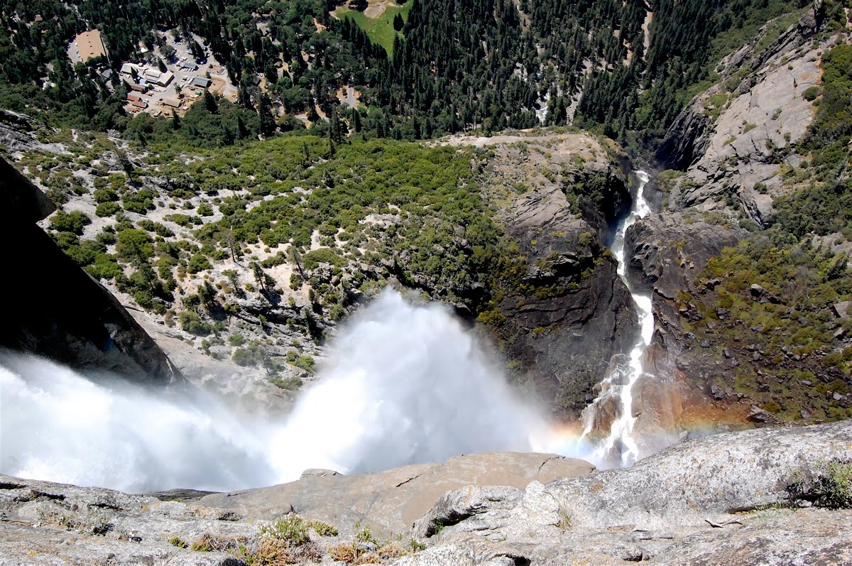
This morning, after breakfast, Ingrid and I decided to give our bikes a rest and go for a hike. Starting at Happy Isles, we climbed the Mist Trail (see top photo) to the top of Vernal Falls. We then continued on the north side of the river to the top of Nevada Falls, crossed over a bridge above the falls, and then followed a piece of the John Muir trail on the south wall down to Vernal Falls where we again picked up the Mist Trail for the final descent.


It was a beautiful hike with crystal blue skies, warm weather, and (at least for the morning) light crowds.


Photos:
Top: Mist Trail
2nd: Tioga Road from about 2/3 the way up the climb
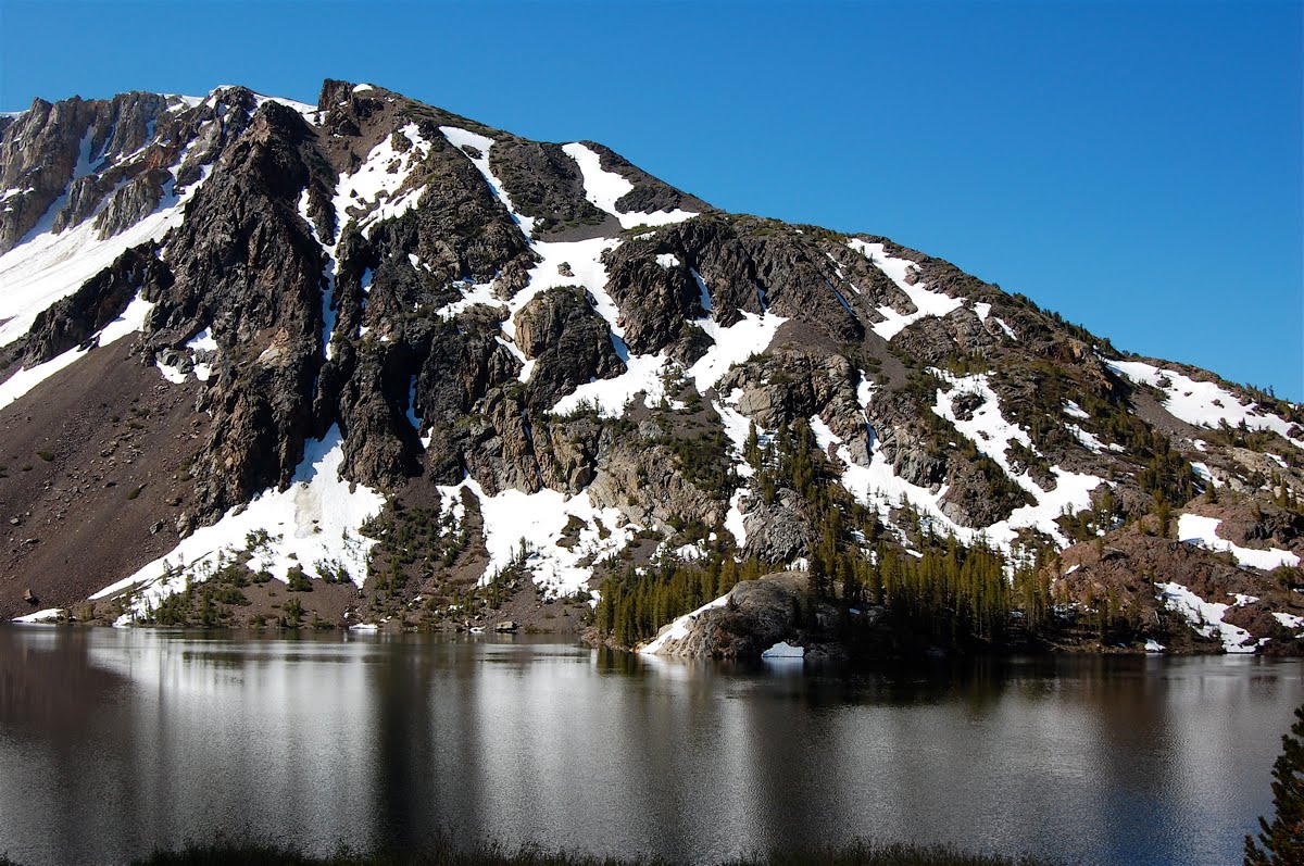
3rd: Ellery Lake, the first landmark after the crest of the steep climb up Tioga Road
4th: Tuolumne Meadows had a lot of snow this year!
5th: Half Dome (of course) from the valley floor
6th: View from the top of Nevada Falls
7th: Liberty Cap and Nevada Falls from the John Muir Trail
Bottom: Looking down on Vernal Falls from the John Muir Trail

Sunday, June 27, 2010

Conway Summit to Lee Vining


27 June 2010

Today we rode from Bridgeport to Lee Vining. The distance was only about 27 miles. We had one serious climb, about 1700 feet. The real work started about 6 miles south of Bridgeport and the grade continued for about seven miles until we reached the Conway Summit (8138 feet). All along this portion of the ride, we had delightful views of the snow-clad Sierra to the west.


The shot above illustrates the riding conditions along 395. Wide open spaces, decent shoulder, moderately heavy traffic including many motor homes and tractor-trailer rigs.


The views to the west were consistently nice for this first half of the ride, as seen in the shot above.


As the descent begins from Conway Summit, the road bends to the east to an overlook of Mono Basin and Mono Lake.


We stopped at a county park along the northwest corner of the lake and walked on a pretty boardwalk past a watercolor artist and through stranded tufa columns to a vantage point near the shore from which we had nice views of the shorebirds.


Mono Lake is a curious place. It has no water outlets, only evaporation. So, over time, it has become highly alkaline, with mineral content about 3x as much as the ocean. Brine shrimp and a peculiar black fly that can walk underwater grow in abundance. Many birds use islands on the lake as nesting areas (sea gulls) or use the lake as a resting and refueling station during long north-to-south migrations. Los Angeles began diverting fresh water streams that feed Mono Lake in the 1940s, which caused the lake level to drop dramatically, revealing many tufa columns, which formed when calcium-rich freshwater springs beneath the lake's surface mixed with carbonate-rich lake water. Over the decades, the lake also became much more alkaline. To protect the ecosystem, the withdrawal of freshwater from streams that feed Mono Lake has been substantially curtailed. The lake level is slowly recovering to a compromise target level of 6392 feet (above sea level) that is well below the pre 1940 value (6417 feet) but higher than the mid 1990s low point (6385 feet). The shoreline is shallowly sloped, so even a few feet of elevation change makes a big difference in the lake surface area.


Lee Vining is just a few miles beyond Mono Lake. After arriving at the motel and showering, Ingrid and I followed a pleasant nature trail along the Lee Vining Creek back to the Mono Lake visitor center. Tomorrow, we tackle the Tioga Road up to Tioga Pass, a climb of 3200 feet to almost 10,000 feet in elevation.

Saturday, June 26, 2010

Devil's Gate Summit to Bridgeport


26 June 2010

Two years ago, Alison and John, Ingrid and I did a self-contained version of the Tahoe-Yosemite ride we are now on. A few days into that ride, dry lightning storms caused numerous forest fires that blanketed northern California in smoke for a few weeks. The first day we encountered that smoke was on the ride from Walker to Bridgeport. Today, the scenery on that same ride was spectacular.


Bridgeport, at an elevation of 6460 feet, sits at the edge of a huge grazing meadow. To the west, the eastern ridge line of the Sierra Nevada is in clear view and the rugged peaks are still laced with snow. Today, the meadow is full of purple irises. The sky was bright blue and in the afternoon cumulus clouds formed.


The main part of today's ride was relatively easy: 30 miles and 2100 feet of elevation gain. An interesting wrinkle is that the climbing started in Walker and continued with almost no break for 18 miles until we reached Devil's Gate Summit. This means that the average pitch was only 2% (100 feet gained per 5000 feet traveled equates to about 2100 feet gained in 18 miles). But even a 2% grade can knock about my speed down by about a third, from 15 mph on flat ground to 10 mph.


After lunch, Ingrid and I did the ride "option," a 27 mile out-and-back ride to Twin Lakes. The route took us across the giant meadow to the west and then climbed about 800 feet into a basin tucked neatly into the foot of the eastern ridge of the mountains. In all, we rode 58 miles today, which will be our longest day of the trip.


The photos:
top — looking west along 395 just outside of Bridgeport
2nd-4th shots — scenes along the road between Walker and Devil's Gate Summit
5th photo — happy cows grazing in the meadow as we ride out to Twin Lakes
bottom — from the eastern shore of the eastern Twin Lake, looking west.

Friday, June 25, 2010

Monitor Pass to Walker


25 June 2010

Today was one of the harder riding days on this trip. From Sorenson's to Markleeville, then a long climb up to Monitor Pass before a long descent to the east side of the Sierra and a ride down Hwy 395 to the small town of Walker. In all, we rode about 44 miles and climbed 3800 feet. The climb to Monitor Pass was about 2800 feet in about 8 miles.


Overall, we did fine, completing the ride in 4 hours of seat time and just over 5 hours total. Both Ingrid and I took the climbing portions slowly and steadily. There is one place that rises steadily at about a 10% grade for almost 2 miles. I slowed to about 3.5 miles per hour (no more than a moderately fast walking pace) and got into a rhythm that I felt I could sustain for as long as I needed to. It helped (a lot) that we had ridden this way before, two years ago. Much of the challenge of climbing is mental and knowing the challenge helps preparing to face it.


It rained for almost the entire two hour climb up to the pass. For the first hour it was a light drizzle that we just tried to ignore. But for the second hour the rain fell steadily and we got wet. I had just enough to cope comfortably: rain pants, a fleece vest, and a light nylon jacket plus a change of clothes in a zip-lock baggie that I put on at the pass. The sag truck was stopped halfway up and Ingrid took shelter in it for the heaviest part of the rain. By the time we began descending on the drier, Eastern side of the Sierra, the rain slackened and the road was only damp.


I had been very much looking forward to the photo opportunities along the upper half of the ride up to Monitor Pass. The wildflowers were riotously blooming. But the dark gray sky and the wet weather made me focus on completing the ride efficiently (and staying warm) rather than taking photos.


This is the group (minus me, taking the photo, and minus Rod, recovering from a stroke).

Thursday, June 24, 2010

Luther Pass to Sorenson's


24 June 2010

Today we had a short ride, south from South Lake Tahoe, up over Luther Pass and then down to Sorenson's, an all-seasons resort at the edge of the Hope Valley. The ride covered 20 miles with a 1600 foot climb and we were in by noon.


After a nice, slow lunch on the deck, Ingrid and I headed off on a hike covering about 7 miles and climbing about 1000 feet to the top of an interesting overlook. It was fantastic. Throughout the lower part the quaking aspen were in fresh green leaf and there were myriad wildflowers in bloom. On the upper half we hiked through forest of pine and sequoia. Tomorrow is the first of two major climbs on this trip, over Monitor Pass and then down to the east side of the Sierra Nevada.


Top photo: South Lake Tahoe.
Middle photo: Road construction led to the signs at the summit being down.
Bottom photo: Near the top of our hike.

This is a short post because it is late and the internet connection is weak.

Wednesday, June 23, 2010

Emerald Bay


23 June 2010

We spent our first two nights on this trip at Sunnyside Lodge a few miles south of Tahoe City. It was an excellent place situated on the lake with large rooms and a fine complimentary breakfast. This morning, I got up early to work for a few hours and then after breakfast we packed up for the ride along the west shore to South Lake Tahoe.


I had a minor bike problem so we first rode the wrong way back to Tahoe City to get it fixed. That gave Ingrid a chance to buy some pink-trimmed Teva sandals she'd had her eye on. I also bought a pair of walking shorts since I'd forgotten to pack any. (Silly me, I'm packed for a much colder ride than we're experiencing.)


The ride was lovely and we took it at a slow pace. For a long stretch, we rode on a bike trail that paralleled the main road. We were treated to views of the lake from angles that changed as we progressed. At a deli/market in Tahoma, we bought a tuna "manwich" (Ingrid's description because it was mammoth) and some coleslaw to share for lunch. After a hard climb to (DL) Bliss State Park the road leveled out.


For lunch, we stopped at the Eagle Falls trail head just across from Vikingsholm at the head of Emerald Bay and hiked the short distance up to a lovely vista. The chipmunk was an uninvited lunch guest!


From the vista point overlooking Emerald Bay, the ride continued for 12 miles, first traversing a narrow ridge with views of water on both sides and then dramatically descending through a series of hairpin turns. We found the head of the bike path, rode past Camp Richardson, and then through the back streets of South Lake Tahoe, ending at the Timber Cove Lodge where we have a room overlooking the lake.


The photos, from the top:
1. Emerald Bay from a view point above Vikingsholm.
2. A view looking south from an early part of today's ride.
3. Our lunch perch near Eagle Creek Falls overlooking Emerald Bay.
4. Our uninvited lunch guest (not at all bashful!).
5. The narrow ridge top road south of Emerald Bay.
6. The view from (5) looking east.

Tuesday, June 22, 2010

Truckee


22 June 2010

Today was set aside for acclimatization. So, we are staying tonight again in Tahoe City. (A sad story: Rod, a 77-y participant on the trip, suffered a stroke while riding today. The good news is that it happened just outside of Truckee and the emergency response and the hospital care have apparently been excellent. He's doing well under the circumstances, but the circumstances are difficult.)


I had an overdue commitment to contribute to a major research proposal and so spent all morning and into the early afternoon squirreled away in my room writing. Ingrid meanwhile did the recommended easy ride over to Squaw Valley. She came back to the room at about 1:30, just as I was finishing. We headed over to the Tahoe House a first-rate bakery/coffee shop/deli for an excellent lunch (grilled vegetable sandwich on Squaw bread). Then she headed back to the hotel for a restful afternoon while I rode over to Truckee on an out-and-back.


The trip stats: 33.5 miles, probably 1000 feet of elevation gain. The riding was fast, probably averaging 15 miles per hour. The riding felt easy and I got to wondering whether the lower air pressure at altitude means significantly less drag and whether that might compensate at least a bit for the greater difficulty of supplying oxygen to my muscles.


Old downtown Truckee had an interesting mix: modern elements that would appeal to the ski crowd along with some historical remnants as depicted in the first three shots. Weather was absolutely perfect! The cycling conditions were a bit of a mixed bag: scenic off-road bike trail along the river for the first and last quarter of the ride (see below) but less pleasant riding on a wide shoulder of the busy and noisy main highway between Squaw Valley and Truckee. Still, it was a fun outing.

Monday, June 21, 2010

Tahoe City


21 June 2010

Happy summer solstice!

Today marks the beginning of an 11-day vacation. We're cycling from Lake Tahoe to Yosemite on a Bicycle Adventure Club (BAC) trip led by our friend Alison. In all, there are about 18 of us on the trip. Ingrid and I are the youngest. Everyone else is retired!


The logistics of a trip like this are challenging. Fortunately, Alison is a master. We took our bikes to her house on Saturday, with pedals off and handlebars rotated. There, they were loaded into a panel truck so that she and Johno could drive up to Reno on Sunday. Yesterday, I took John down to the airport to pick up a one-way rental minivan so that he could could drive six of us to Reno today where everyone was meeting. There, after lunch, we climbed into a minibus for the hour long mostly return trip back up to Tahoe City on the NW shore of magnificent Lake Tahoe.


There were some adventures, such as rear brakes on the panel truck that didn't work. But in the end, everyone made it here safely and on time. The sky is brilliantly blue. We had some nice afternoon thunder over the lake and a brief, light shower with the largest raindrops I can ever remember seeing.


Tomorrow we are taking a local ride to get a bit acclimatized to the altitude. Then on Wednesday we are heading south.